
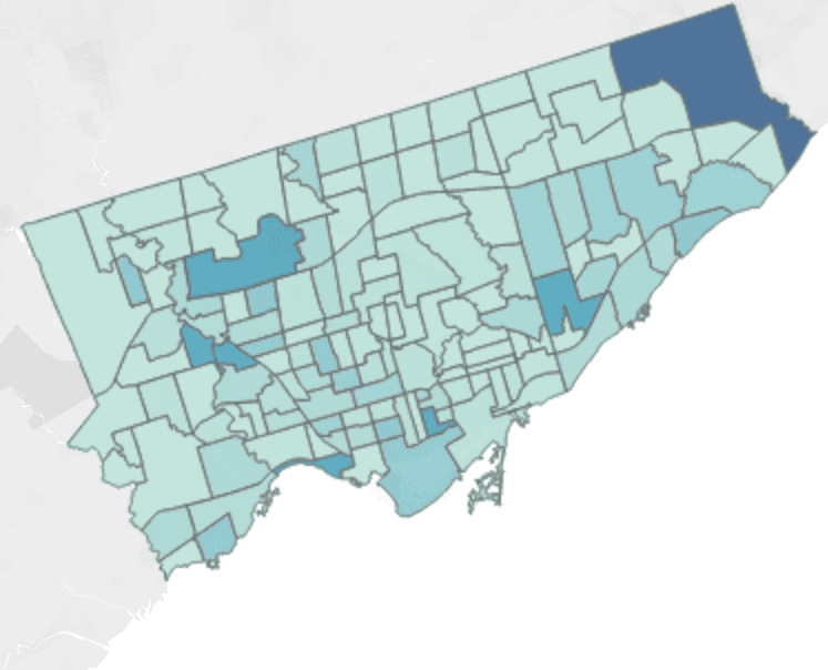
TORONTO, ON., May 27, 2020 — Today, Toronto Public Health unveiled an interactive map on the City of Toronto website that highlights each of the city’s neighbourhoods and their COVID-19 case numbers.
Mayor John Tory said he believes the new information will do “far more help than it will do harm,” as a reminder that COVID-19 is still here in the city and “we must be vigilant in following public advice.”

A close look as you hover the mouse over each area of the city, reveals that there are more cases in the northerly parts of the city to the east and west. But it also reveals that cases have been reported in every area of the city.
“Our data confirm that COVID-19 is present in every single neighbourhood in Toronto,” said Dr. Eileen de Villa, Toronto Medical Officer of Health. “At this time, based on the last two weeks of activity, our mapping indicates that people living in the northwest and the northeast parts of the city now have the highest number of positive cases.”
However, Dr. Eileen de Villa said “where a person lives does not necessarily indicate where they picked up COVID-19. The reality is you are at risk of getting COVID-19 anywhere when you are in close contact with the respiratory droplets of someone who is infected with the virus.
Toronto’s top doctor also said that those people looking at the map “may mistakenly believe that there is an elevated risk of infection by going to certain parts of the city. This in turn contributes to misinformation and unintended stigma. We all have a shared responsibility to not create unnecessary social, physical or other harms in our community.”
“These numbers represent people, people in our city,” said Dr. de Villa. “It is important to keep in mind that these maps reflect where people live and they do not necessarily reflect where they were exposed.”
Meanwhile, 152 new COVID-19 infections were reported in Toronto. To date, 7,814 people have recovered, an increase of 187 since yesterday.
Dr. de Villa said the Toronto Public Health’s goal is “to bring down the reproduction number to less than 1. This means that each existing infection causes less than one new infection,” explained Dr. de Villa. “In this circumstance, disease activity declines and virus spread eventually stops.”
Toronto’s current reproduction number in the community is 1.1. which means “we must continue our public health measures for now. his means washing your hands frequently, practising physical distancing, staying within your household bubble, essentially following all of the advice we have provided over the past several weeks,” Dr. de Villa emphasized.
And in light of the mob scene at Trinity Bellwoods Park last weekend, the City has decided to help illustrate proper physical distancing measurements there better by painting distancing circles on the grass. This approach has been working in cities such as San Francisco and New York City.


You must be logged in to post a comment.