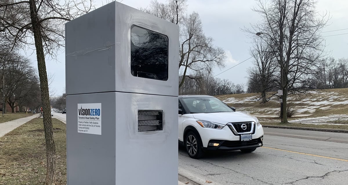
The City of Toronto’s 50 Automated Speed Enforcement (ASE) devices will begin rotating to the third round of locations in May to reduce speeding at more areas with safety concerns, encourage a wide-ranging deterrent effect and raise public awareness about the need to slow down and obey posted speed limits.
As per provincial guidelines, warning signs have been installed at all new locations to warn drivers in advance. Warning letters will not be issued in lieu of tickets.
The next 50 Toronto ASE locations are:
- Martin Grove Road, north of Garfella Drive (Etobicoke North)
- John Garland Boulevard, near Kendleton Drive (Etobicoke North)
- The East Mall, south of Capri Road (Etobicoke Centre)
- La Rose Avenue, east of Griggsden Avenue (Etobicoke Centre)
- Algoma Street, east of Royal York Road (Etobicoke-Lakeshore)
- Lake Shore Boulevard West, near Twentieth Street (Etobicoke-Lakeshore)
- Windermere Avenue, near St. Olave’s Road (Parkdale-High Park)
- Annette Street, near Laws Street (Parkdale-High Park)
- Guestville Avenue, near Dennis Avenue (York South-Weston)
- Culford Road, north of Burr Avenue (York South-Weston)
- Wilson Avenue, near 1196 Wilson Ave. (York Centre)
- Northover Street, south of Sheppard Avenue West (York Centre)
- Shoreham Drive, west of Gosford Boulevard (Humber River-Black Creek)
- Stong Court, west of Driftwood Avenue (Humber River-Black Creek)
- Wilson Avenue, west of Belgrave Avenue (Eglinton-Lawrence)
- Marlee Avenue, south of Hillmount Avenue (Eglinton-Lawrence)
- Dufferin Street, near Waterloo Avenue (Davenport)
- Concord Avenue, north of College Street (Davenport)
- Dundas Street West, near Augusta Avenue (Spadina-Fort York)
- The Esplanade, east of Princess Street (Spadina-Fort York)
- Avenue Road, near Macpherson Avenue (University-Rosedale)
- Clinton Street, north of College Street (University-Rosedale)
- Davisville Avenue, near Acacia Road (Toronto-St. Paul’s)
- Bansley Avenue, south of Vaughan Road (Toronto-St. Paul’s)
- Homewood Avenue, near Maitland Place (Toronto Centre)
- Parliament Street, north of Oak Street (Toronto Centre)
- Greenwood Avenue, south of Glebeholme Boulevard (Toronto-Danforth)
- Plains Road, near Milton Road (Toronto-Danforth)
- Blythwood Road, near Blyth Hill Road (Don Valley West)
- Leslie Street, south of Lawrence Avenue East (Don Valley West)
- York Mills Road, east of Rayoak Drive (Don Valley East)
- Grenoble Drive, west of Spanbridge Road (Don Valley East)
- Van Horne Avenue, west of Brian Drive (Don Valley North)
- Parkway Forest Drive, near 25 Parkway Forest Dr. (Don Valley North)
- Drewry Avenue, east of Norwin Street (Willowdale)
- Ellerslie Avenue, west of Diagonal Road (Willowdale)
- Victoria Park Avenue, near Medonte Avenue (Beaches-East York)
- Secord Avenue, near Palmer Avenue (Beaches-East York)
- Birchmount Road, south of Sadler Drive (Scarborough Southwest)
- Bellamy Road, south north of Kingston Road (Scarborough Southwest)
- Gilder Drive, east of Midland Avenue (Scarborough Centre)
- Lawrence Avenue East, west of Ben Stanton Boulevard (Scarborough Centre)
- Bamburgh Circle, near 125 Bamburgh Cir. (Scarborough-Agincourt)
- Chester Le Boulevard, near Pettibone Square (Scarborough-Agincourt)
- Huntingwood Drive, near Mollard Road (Scarborough North)
- Heather Road, east of Glen Watford Drive (Scarborough North)
- Military Trail, near 341 Military Tr. (Scarborough-Guildwood)
- Gatesview Avenue, east of Cedar Drive (Scarborough-Guildwood)
- Sewells Road, west of Glenheather Terrace (Scarborough-Rouge Park)
- Centennial Road, south of Cherrydale Court (Scarborough-Rouge Park)
The City says Site selection is primarily based on data that indicates where speed and collision challenges exist near schools in Community Safety Zones. Additional considerations include avoiding areas of planned road work, speed limit changes, obstructions or impediments to equipment and limited boulevard space.
“The data we have so far proves that Automated Speed Enforcement is a strong deterrent against speeding, and we will continue to rotate speed cameras in the city to cover as many areas as possible,” said Mayor John Tory. “All new locations have been selected following a data-driven approach that prioritizes areas in the city with speed and collision challenges. This is just one part of our ongoing Vison Zero traffic safety work – which includes road redesigns, lower speed limits, and increased enforcement – to make our streets safer for everyone,” said Mayor Tory.
A map of all current and planned locations is available here
The ASE program is aimed at increasing road safety, reducing speeding and raising public awareness about the need to slow down and obey posted speed limits. The 50 ASE devices are installed city-wide on local, collector and arterial roads in Community Safety Zones near schools. Each ward has two ASE devices that capture and record images of vehicles travelling in excess of the posted speed limit.
More information about the program, how to settle fees and how to request an ASE device is available here.
Other articles from totimes.ca – otttimes.ca – mtltimes.ca